When the Railroads Came to Hopkins County
By Thomas J. Minter
When the 1870’s rolled around Jefferson, Texas, had been a port city since 1844. It was second only to Galveston. From it supplies moved over the Jefferson Wagon Road, and its branches, to the settlements in the interior of Texas. And from these same settlements, raw materials and goods were hauled to Jefferson to be shipped out. This was truly the “mother road” of its time.
But in the early 1870s some business men in Jefferson began to worry about the threat of the railroads which were being planned and built. The fear was Jefferson may be bypassed in an economic sense.
The company was chartered on March 22, 1871 for a railroad to run from Jefferson to Sherman, and from there to the western boundary of Texas. The route was somewhat vague and seemed to depend on the financial incentives offered by towns along the way.²
For the railroad to operate in Texas, it had to have a separate charter, which was St. Louis Southwestern Railway Company of Texas. The business offices were located in Tyler, Texas, which was located on the main line from Mt. Pleasant to Gatesville to the west.  The Cotton Belt Route was of standard gauge9 and was a single track system.
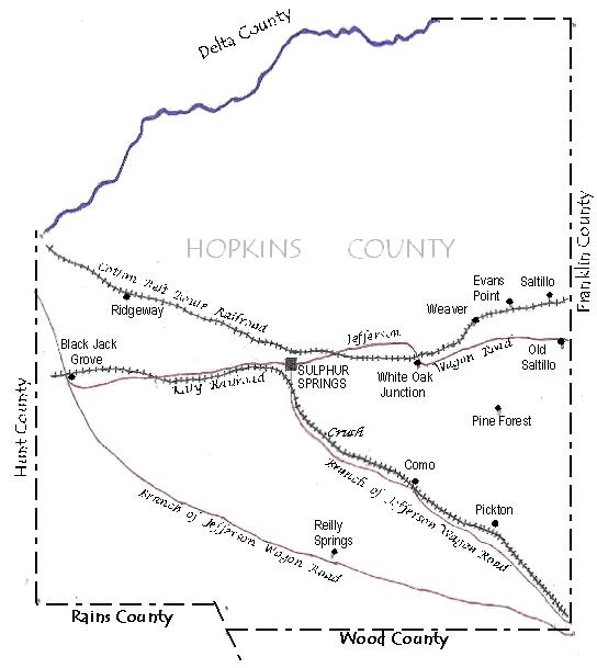
Going on a few more miles to the west, another town was established with a station called "Weaver," which resulted from the line bypassing White Oak Junction a few miles on west, which had been a prominent place on the Jefferson Wagon Road. The White Oak Junction post office was moved to Weaver. The railroad first wanted to name the the town "Dupree" after some prominent first settlers. But the family objected, and it was named Weaver after the first sheriff of the County.1²
Southeast of Sulphur Springs near the Katy Railroad was a community causally called "Crush," which was named after a big rock crusher it had which produced aggregate for the railroads. In 1900 Crush got a more formal name of "Thermo."13
Not only did the railroads stimulate economic development in trade, but the Cotton Belt Route in particular was the biggest taxpayer in the county, which aided government and schools.18
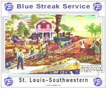
The Cotton Belt Route gave its freight service the title of “Blue Streak,” and advertised its trains as being “on time . . . all the time.” It took a freight train 55 hours, including its stops to make it from St. Louis to the end of the line at Gatesville, Texas.
Both Katy and the Cotton Belt had named passenger train service. The Cotton Belt operated passenger service from St. Louis to Texas points and from Memphis to Shreveport and Dallas. Cotton Belt's Lone Star operated from Memphis Union Station to Dallas Union Terminal with a branch from Lewisville, Arkansas to Shreveport, Louisiana. The Morning Star was the second named train over much of this route, operating out of St. Louis Union Station.19
______
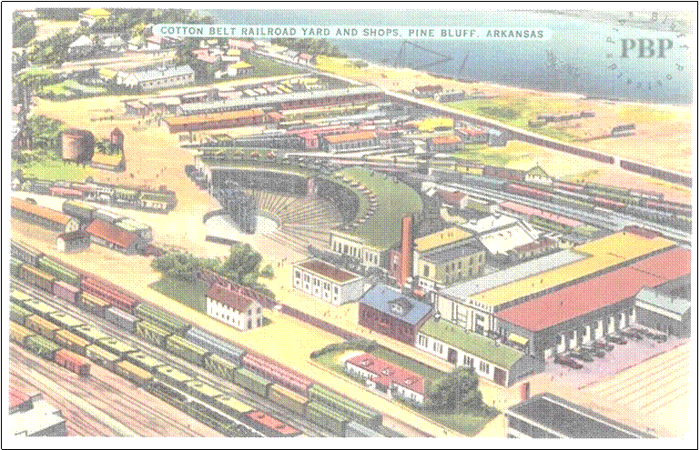
Note: The writer visited the Pine Bluff, AR, railroad museum in 2010, which has rolling stock for viewing as well as many displays of Cotton Belt Route memorabilia. Well worth the trip.
He also visited Jefferson, TX, in 2009 where Jay Gould’s personal railcar is on display.
Many times he has passed through East St. Louis, where the Cotton Belt Railroad’s marshalling yards were located. These yards, still being used by railroads, are still called “Cotton Belt Rail Yards,” although the railroad no longer exists.
He has also visited Union Station in St. Louis’s where there were tracks under roof for 31 trains to take on passengers, and where the Cotton Belt passenger trains went forth. In its heyday, this terminal served 22 railroads. St. Louis is also the location of the Cotton Belt Railroad’s freight depot, which although decrepit and defaced with vandals’ graffiti, still defiantly stands today.
* * *
Notes:
1. George C. Werner, "East Line and Red River Railroad," Handbook of Texas Online. http://www.tshaonline.org/handbook/online/articles/eqe01), accessed March 21, 2011. Published by the Texas State Historical Association.
2. Ibid.
3. Ibid.
4. Orren, G. G., “History of Hopkins County,” East Texas State Teachers College, Master of Arts Thesis, 1938. p. 131.
5. Christopher Long, "Pickton, TX," Handbook of Texas Online http://www.tshaonline.org/handbook/online/articles/hnp28), accessed March 20, 2011. Published by the Texas State Historical Association
6. Donovan L. Hofsommer, "Missouri-Kansas-Texas Railroad," Handbook of Texas Online (http://www.tshaonline.org/handbook/online/articles/eqm08), accessed March 30, 2011. Published by the Texas State Historical Association
7. Ibid.
8. Encyclopedia of Arkansas History & Culture. http://www.encyclopediaofarkansas.net/encyclopedia/entry-detail.aspx?entryID=5104
9. Ibid.
10. J. E. Jennings, "Saltillo, TX," Handbook of Texas Online (http://www.tshaonline.org/ handbook/online/articles/hls07), accessed March 30, 2011. Published by the Texas State Historical Association.
11. Christopher Long, "Evans Point, TX," Handbook of Texas Online (http://www.tshaonline.org/handbook/online/articles/hve37), accessed March 21, 2011. Published by the Texas State Historical Association.
12. “History of Weaver,” http://www.rootsweb.ancestry.com/~txhopkin/gen/resources/histories/community/weaver.html
13. Christopher Long, "Thermo, TX," Handbook of Texas Online (http://www.tshaonline.org/handbook/online/articles/hrt16), accessed March 29, 2011. Published by the Texas State Historical Association.
14. “Ridgeway,”
http://www.rootsweb.ancestry.com/~txhopkin/gen/resources/communities.html
15. Orren, p. 93.
16. Ibid., p. 96-7.
17. Bob and Michelle Gilbert, "Hopkins County," Handbook of Texas Online (http://www.tshaonline.org/handbook/online/articles/hch18), accessed March 29, 2011. Published by the Texas State Historical Association.
18. Orren, p. 131.
George C. Werner, "St. Louis Southwestern Railway," Handbook of Texas Online (http://www.tshaonline.org/handbook/online/articles/eqs27), accessed March 21, 2011. Published by the Texas State Historical Association.
19. “Cotton Belt Passenger Service,” http://www.absoluteastronomy.com/topics/St._Louis_Southwestern_Railway
20. “Missouri-Kansas-Texas Railroad,” http://en.wikipedia.org/wiki/Missouri%E2%80%93Kansas%E2%80%93Texas_Railroad
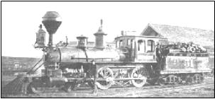
A narrow gauge locomotive. The early ones on the East Line and Red River Railroad used wood to fuel their boilers.
The Cotton Belt's shops at Pine Bluff in their heyday. A railroad museum in now located in one of the few remaining buildings.
An advertisement put out by the Cotton Belt Route.
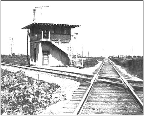
At Left: Near Greenville, Texas, where the Cotton Belt Route and the Katy Railroads cross. The track straight ahead is looking toward Commerce, Texas, on the Cotton Belt. The track to the left is the Katy toward Denison,Texas. "Interlocking towers" controlled movement on the intersecting tracks.